Beyond Bhu-Aadhaar: Can India’s Land Stack Work Harder for the Farmer?
India’s Land Stack is moving beyond digitised land records through Bhu-Aadhaar and interoperable GIS systems. The next challenge is connecting land identity with water, irrigation, infrastructure and rural services while protecting farmer control and data accuracy. Its success should be measured by reduced paperwork, faster services and better-informed land and water decisions.

 Join the RuralVoice whatsapp group
Land Is More Than a Boundary
For a farmer, land is rarely just a boundary on a map.
It is soil, water, access, livelihood and often the family’s most important asset. Its productivity depends on many things beyond ownership. A borewell may provide irrigation. A canal may cross nearby. A farm road provides access to market. A storage shed protects produce. A pump, electricity connection or drainage channel may be essential to making the land productive.
Yet information about these things can sit in different offices and different records.
An Older Understanding of Interdependence
The connection between land, water and food is not a new idea in India. The Bhagavad Gita expresses this relationship simply:
अन्नाद् भवन्ति भूतानि पर्जन्याद् अन्न-सम्भवः
annād bhavanti bhūtāni parjanyād anna-sambhavaḥ
— Bhagavad Gita, 3.14
“Living systems depend on food, rainfall and reciprocal ecological processes.”
The language is ancient, but the relationship remains familiar to every farmer. Land cannot be understood separately from water, food production and the wider systems that sustain it.
India’s emerging Land Stack creates an opportunity to reflect that interdependence in a modern form. It can begin by connecting information that today sits in different offices and different records.
A Digital Identity for Every Parcel
Under the Digital India Land Records Modernization Programme (DILRMP), India has already made substantial progress in digitising land records and cadastral maps.
The next phase, DILRMP 3.0 for 2026–31, moves further towards a GIS-enabled Land Stack. The intention is to bring land maps, ownership information, registration and other land-related records into an interoperable digital ecosystem.
An important part of this transformation is the Unique Land Parcel Identification Number, or ULPIN, commonly called Bhu-Aadhaar.
It gives a land parcel a unique 14-digit identity based on its geographical location. More than 40 crore parcels had received ULPINs by August 2026, according to the Department of Land Resources.
That is an important foundation. But it also raises the next question.
Once we can reliably identify the land, how much more useful could that identity become for the farmer?
Land Does Not Work Alone
Consider a farmer looking at the coming season.
Knowing the legal identity and boundary of the farm is important. But the farmer may also need to know the condition of the water source, the irrigation available to the parcel, groundwater conditions, access to a watershed structure, or whether nearby infrastructure is functioning.
Today, such information may come from different departments and systems.
The answer should not be to put everything into one enormous government database. Different agencies have different responsibilities. Land officials, irrigation departments, electricity providers, banks and local authorities do not need to surrender control of their records.
What is needed is the ability for these systems to communicate when there is a legitimate reason to do so.
Bhu-Aadhaar tells the system which piece of land we are talking about. The next challenge is connecting that land, where useful, with reliable information about the systems that make it productive.
Water Shows Why Connection Matters
Water provides perhaps the clearest example.
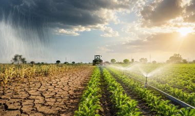
A farmer does not experience water according to departmental boundaries. Rainfall, groundwater, ponds, canals, watershed structures and irrigation systems ultimately meet on the same farm. But the information describing them may not meet so easily.
-What if a farmer could see, through an authorised service, relevant information about the land and the water systems serving it?
-What if a bank assessing an agricultural loan could verify permitted land information without asking the farmer to repeatedly obtain the same documents?
-What if drought planning could combine land, watershed and water information to identify areas facing the greatest pressure?
-And after a flood, what if authorities could more quickly understand which agricultural parcels, access routes and rural assets had been affected?
The Systems Need to Talk
These possibilities require more than digitisation.
They require interoperability: the ability of separate digital systems to exchange useful information while retaining their own responsibilities and controls.
There are already signs of this direction. The Department of Land Resources has linked its Land Stack vision with easier access to formal credit. It is also examining integrated GIS and management-information systems for watershed development. The Department has described sustainable land and water management as important to agricultural productivity and rural livelihoods.
The opportunity is therefore not to invent another portal for the farmer. It is to make existing systems work together more effectively.
Keep the Farmer at the Centre
Technology alone will not solve rural India’s land and water challenges.
A digital record can be wrong. A map can require correction. Connectivity varies. Farmers must have clear ways to challenge inaccurate information. Access must work in local languages and should not assume that every farmer is comfortable navigating a complex digital service.
Digital systems should reduce administrative effort, not transfer more of it to the farmer.
Measure What Becomes Easier
The success of the Land Stack should eventually be measured not only by how many records are digitised or parcels receive identifiers. It should also be judged by whether reliable information becomes easier to use.
-Can a farmer obtain a service with fewer visits to government offices?
-Can the same verified information be reused instead of repeatedly submitted?
-Can land and water decisions be made with a better understanding of local conditions?
-Can institutions respond faster when drought, flooding or infrastructure failure affects rural livelihoods?
These are practical tests.
From Better Records to Better Rural Services
India has already taken a significant step by giving land parcels a persistent digital identity.
The next opportunity is larger.
Bhu-Aadhaar can tell us which land we are talking about. A connected Land Stack could help us understand what that land needs to remain productive.
For the farmer, that is where digital land reform can begin to move from better records towards better rural services.
(Apurva Pathak is an architect and design-governance professional based in New Zealand, with experience across India, New Zealand and the Gulf. He writes on digital public infrastructure for the built environment, federated governance, infrastructure resilience and persistent asset identity. )
LinkedIn: https://www.linkedin.com/in/apurvapathak-designgovernance/